Add as preferred on Google
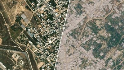
The center of Rafah as it appears on Apple Maps (left) and on Google Maps (right). Montage by L’Orient-Le Jour. Images: Apple Maps; Google Maps, ©2026 Airbus, CNES / Airbus, Maxar Technologies. Add as preferred on Google More than half of all buildings destroyed and more than eight in 10 damaged: According to the U.N., the Gaza Strip bears little resemblance to what it was before the war. But this destruction is not reflected in everyone’s view of the territory: Since Nov. 1, posts viewed millions of times have accused Apple of erasing signs of destruction from its Maps app. According to the posts’ authors, the app initially displayed images of the ruins, as Google Maps does, before quietly replacing them with prewar images showing buildings in Rafah and Khan Younis still standing.According to L’Orient-Le Jour’s research, the rumor began circulating Nov. 1, 2026, with a post by the X account @RabbiJeffx that was viewed more than a million times. The post juxtaposes an image of Gaza in ruins, purportedly taken from Google Maps, with an image of an... You have reached your article limit.Stay informed as events unfold across a region in flux.Subscribe for $0.5/month for the first 3 months. Subscribe now Log in This article is only available to L’Orient Today subscribers. Subscribe now Log in Create a free account to continue reading this article. You’ll also receive The Morning Brief, our must-read daily digest of Middle East news. Opt out anytime Email Address Password Email Address Password I would like to receive special offers from L'Orient Today as well as selections of the best articles. Register By creating an account, you agree to the terms and conditions of use and our privacy policy. Register Or register with: Facebook
Already have an account? Login here